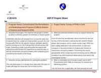
Survey of PFAS in soils
Description
The scope of the web map app is to create a dashboard that details the results of the soil survey. The dashboard will include maps, graphs, photos, and charts. We intend on including the various soil parameter data with PFAS being the focus of the dashboard.
Project Justification
CSRR/DSR collected soil samples from across the state and analyzed them for a wide set of parameters as part of a Soil Survey with PFAS as the specific interest. Multiple reports will be coming out on the findings that include various GIS maps. Publishing a web map along with the reports will allow those with limited GIS experience to view the data. It will aid researchers and policy makers with comparing and visualizing the results of the study.
Attachments
Activity
Show:
Idea
Add watchers
Details
Sponsoring Leadership Area
Site Remediation and Waste Management
Sponsoring Leadership Area's Priority
None
Program Area Lead(s)
Alex Iannone is the lead for the GIS work on the project. Jennifer Willemsen is the lead for the over project.
DOIT technical lead(s)
None
All Involved Leadership Areas
Div. of Information TechnologySite Remediation and Waste Management
Created: 19 June 2025, 19:32
Updated:
19 June 2025, 19:33
 IPTD-563
